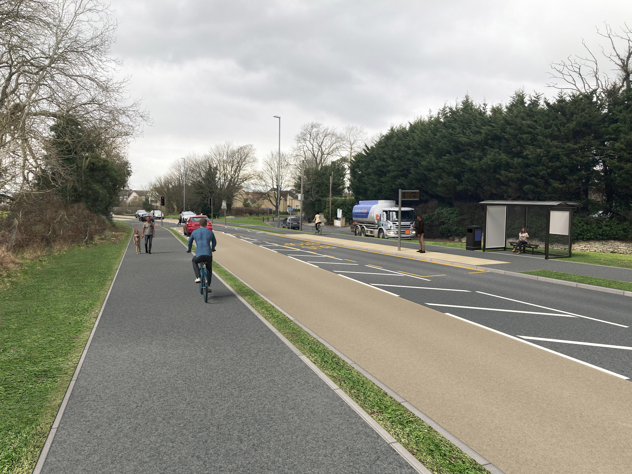
A new scheme is proposed to improve the walking and cycling routes that connect Whitchurch village, Queen Charlton and the National Cycle Network to the community facilities on the other side of the A37 – including the children’s playground, rugby, and cricket clubs.
At the heart of the scheme is a new signalised crossing on the A37 just south of Whitchurch village to help pedestrians and cyclists cross the busy carriageway.
It will also feature two new sheltered bus stops (with real-time bus information), wider paths and footways on both sides of the road, and improved junctions with additional crossing opportunities. The aim is to support people to get around safely and more easily however they choose to travel.

Details of the proposed scheme
View a detailed plan of the proposed scheme
Expand the sections below to read more about each improvement.
- A new 5.2-metre-wide signalised crossing on the A37 will be installed south of Whitchurch village and north of the junction with Queen Charlton Lane.
- It will connect both the National Cycle Network (Route 3) and the residential area in the east, with the community facilities in the west, which include a new sheltered bus stop, the children’s playground, and a rugby and cricket club.
- The ‘toucan’ crossing will help pedestrians and cyclists to cross the busy carriageway.
- Dropped kerbs at the crossing will support cyclists and people pushing buggies or using mobility aids.
- Textured paving alerts people who are blind or partially sighted to crossing opportunities.
- The two existing bus stops in the area will be relocated to accommodate the crossing. They will become sheltered stops with real-time information.
- The bus stop on the eastern side (towards Pensford) will move south by 40 metres.
- The bus stop on the western side (towards Bristol) will move north by 30 metres.
- The long path which connects the community facilities to the new A37 crossing will be widened from 1.5 metres to 3 metres. This will allow cyclists, family groups and people with double buggies or mobility aids to comfortably pass each other.
- The shared path will be set back from the carriageway by a grass verge to improve safety.
- The width of the junction on the A37 with Norton Lane will be reduced to slow approaching traffic.
- A new informal crossing (featuring dropped kerbs and tactile paving) will be installed on Norton Lane connecting the new shared path to community facilities.
- The extension of the shared path on the eastern side of the new signalised crossing will be widened to 3 metres to improve access to the National Cycle Route.
- The shared path will be extended (at the same height) over the existing access road at its junction with Sleep Lane. The bollards at the entrance to the access road will be moved behind the path.
- The footway south of the crossing will be widened from 1 to 2 metres and aligned to the carriageway to support access to the new sheltered bus stop.
- The A37 junction with Queen Charlton Lane will be narrowed to slow approaching traffic.
- A new pedestrian refuge (raised island with dropped kerbs) will be installed on Queen Charlton Lane to help people access the village cemetery.
- An existing small traffic island opposite the Norton Hill Lane junction will be improved to protect the safety of right-turning vehicles. It will include full height kerbs to encourage people to cross at the new signalised crossing.
- The bus stop just south of Norton Hill Lane junction on the eastern side of the A37 will be removed to improve visibility.
Find out more about the community-led Liveable Neighbourhoods programme
Read more about the through-traffic restriction trial and consultation
Next steps
We will consult the public and key stakeholders on the scheme after the full business case (FBC) for the LN programme has been agreed in Spring 2024. The purpose of the FBC is to secure the funding required to install the schemes.
Monitoring
Traffic, walking and cycling data would be collected before and after installation to help us measure the success of the scheme.
Contact us
If you would like to talk to an advisor, get involved in the LN programme or be kept up to date on future events, email us at LNs@bathnes.gov.uk, or call 01225 39 40 25 (and request a call-back from a team member)
