About this page
How this part of the Local Plan Options Document works
These site options pages contain the following sections:
Site background
- A broad description of the site, with map if appropriate
- An overview of development proposed or already in progress
- Relevant aspects of planning policy for this site
- The history and status of any planning applications for this site
Options for the new Local Plan
We may suggest one or more possible approaches:
- Keeping existing plans for this site as they are
- Making small changes to our approach, which may allow for changes
- Replacing the approach with something that is substantially different
- Identifying factors or events which may affect this policy in the future
Each option will have a short analysis:
- Opportunities presented by the site option
- Constraints (obstacles which would need to be addressed)
- Mitigations (Measures that would be needed to reduce any harm development would cause)
- Further information we'd need to make a more in-depth assessment of the suitability of the site or option
Policy context note
- Where decisions about this site or option may affect how we approach other sites (or vice versa), we will add a note to explain
Explore this site option
Select a section below to read more.
7.77 The development options would have vehicular access off the A37, which needs to be downgraded (for example, reducing speeds) as it passes through the village, in order that safe pedestrian and cycle routes and crossings can be provided.
7.78 Green links throughout the residential areas would enhance local biodiversity and provide a high-quality public realm and direct access to the countryside.
7.79 The new development needs to be respectful of the historic character of the village when it comes to connecting to the existing settlement. Historic routes could be used for active travel, and it is important to retain and enhance the local character of the settlement. The setting of the Grade II listed church is an important consideration and would require a sensitive solution.
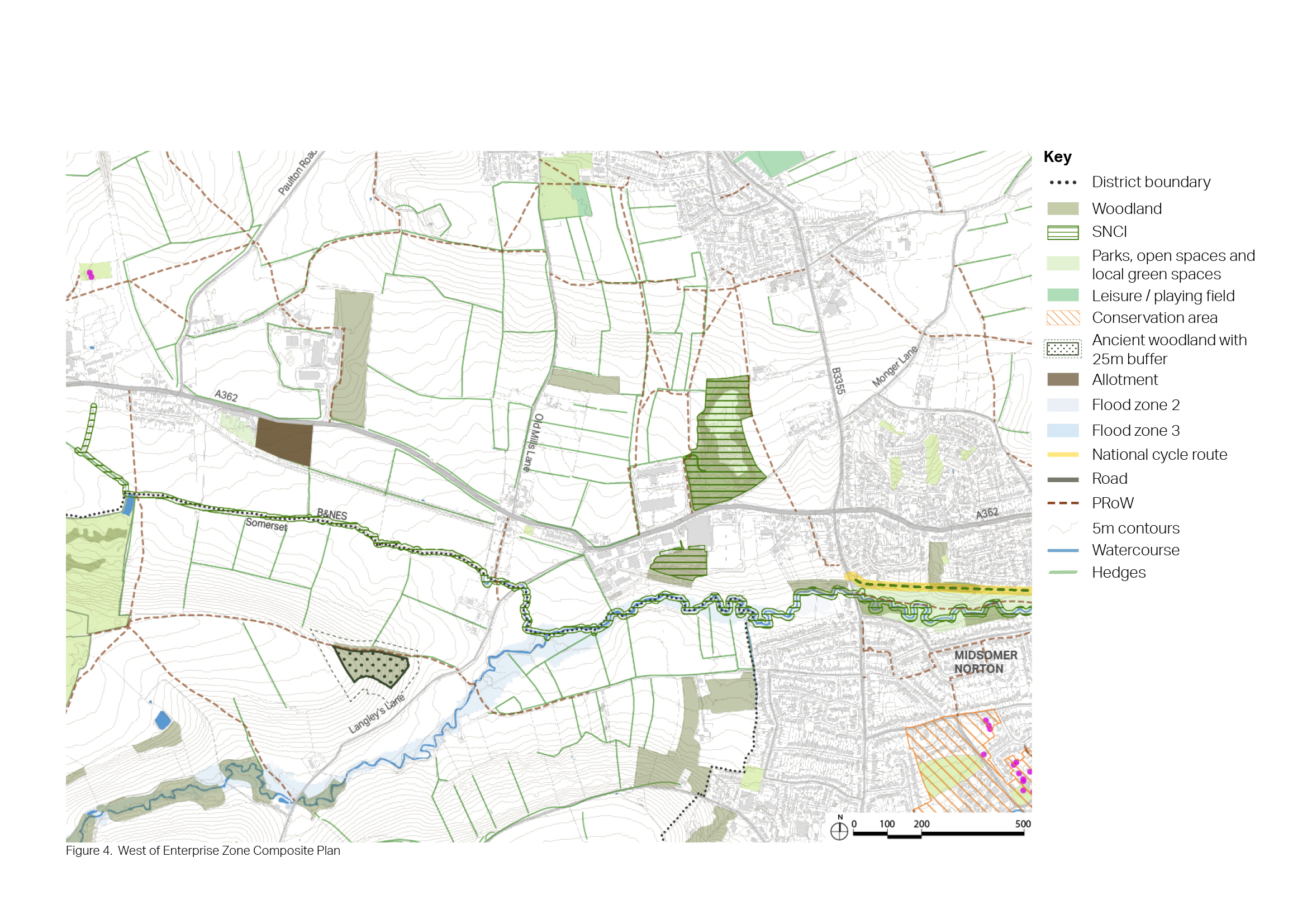
Figure 55: Context Plan - West of the Enterprise Zone
Option A (North development)
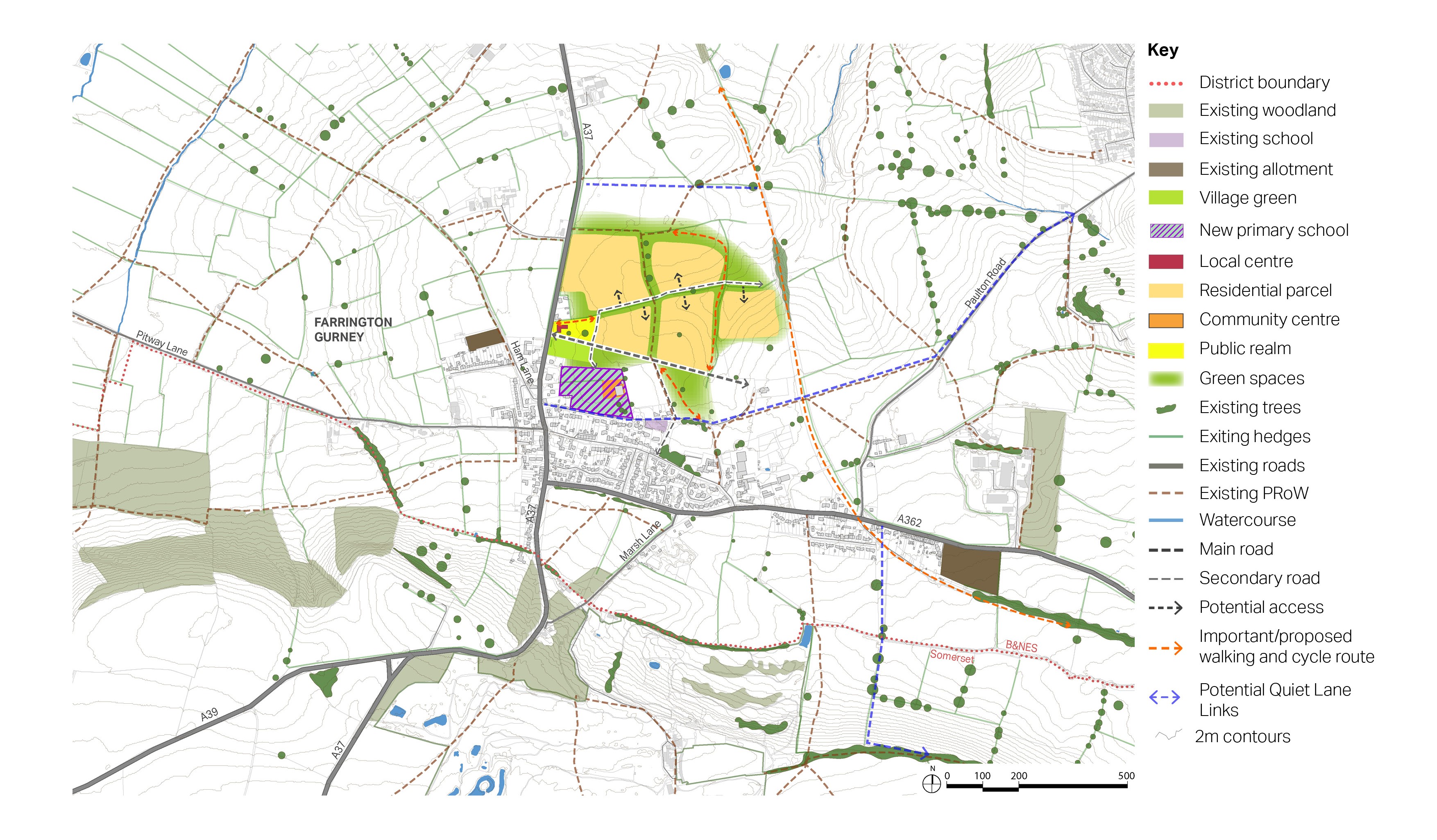
7.80 The development provides a series of green corridors along existing roads and Public Rights of Way, with the enclosing green buffer to the north and east forming a network of open spaces accessible by a system of footpaths and cycleways.
7.81 A new bus route along the A362 would connect with the existing bus services on the A37 corridor, via a new Mobility Hub located at the junction of the A362 and A37. Bus priority at the A37/A362 junction will enhance bus journey times.
7.82 Pedestrian space improvements are proposed along the A37 corridor through Farrington Gurney, comprised of wider footways, a review of pedestrian crossings and signals and a reduction in the speed limit.
7.83 Church Lane could be closed to traffic to improve the north-south pedestrian and cycle links to the existing Farrington Gurney Church of England Primary School.
7.84 Two Quiet Lane Links have been identified running in an east-west alignment on unnamed rural roads to the north of Farrington Gurney.
Figure 58: Indicative Concept Plan - Farrington Gurney Option A (North development) Revised 11.03.24
Opportunities
- Provision of approximately 500 homes, an element of which would be affordable housing.
Constraints
- Setting of the listed church requires sensitive treatment.
- Air Quality Management Area.
- Primary school capacity.
- Agricultural land classification.
- Safeguarded existing sport and recreational facilities. The Recreation Ground is also designated as a Local Green Space.
- Secondary school pupils would need to be transported to Norton Hill School in Midsomer Norton at cost to the Council, and would not be able to reach school using actives modes.
Mitigation required
- New primary school next to the existing community centre
- Landscaping
- Highway works
- Provision of on-site green space (including park and recreation ground
Further investigation or evidence
- Heritage assessment
- Archaeology investigation
- Landscape Assessment
Option B (South development)
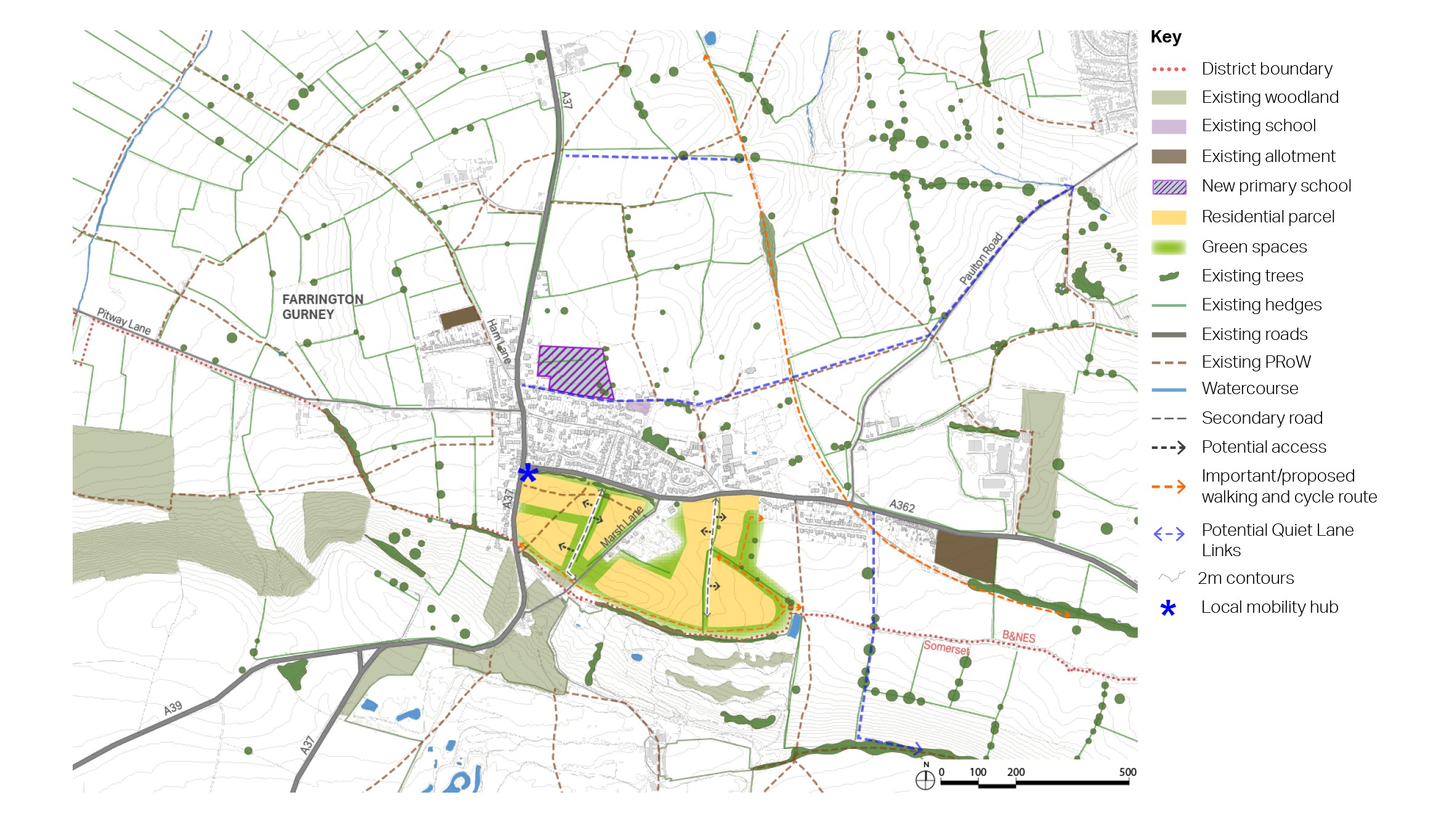
7.85 Option B is a residential development to the south of the A362, with vehicular access off this main road.
7.86 The existing road running through the site (Marsh Lane) would become an important connecting route, providing access to the main body of development. There will be additional green links and active travel routes connecting to the existing village and, in particular to the various amenities and services, such as the school and the Co-op.
7.87 Residential parcels would be located within a series of green corridors and buffers to protect the Site of Nature Conservation Interest (SNCI) in the centre of the area and Rush Hill Wood, an Ancient Woodland to the south. Marsh Lane which connects the two areas of woodland is identified as a Nature Recovery Network opportunity for woodland connectivity. The buffer along the southern boundary also helps protect the setting of the Grade II registered park and garden of Ston Easton Park to the south.
7.88 Planting along the A362, which runs between the existing settlement and the new development would help to integrate it into the settlement, framing views towards the ridge to the south and to key buildings within the existing settlement.
7.89 There would be a need for pedestrian improvements along the A362, which provides access for vehicles and active travel modes to the development. The Somer Valley Links proposes an active travel route along the road to connect with active travel links in Midsomer Norton.
Figure 59: Indicative Concept Plan - Farrington Gurney Option B (South development)Revised 11.03.24
Opportunities
- Provision of approximately 500 homes, an element of which would be affordable housing.
Constraints
- Site of Nature Conservation Importance (SNCI)
- Ancient Woodland
- Mendip Hills
- Agricultural land classification
- Air Quality Management Area
Mitigation required
- New primary school next to the existing community centre
- Highway improvement on the A362
- Landscape buffer to ancient woodland and SNCI
- Secondary school pupils would need to be transported to Norton Hill School in Midsomer Norton at cost to the Council, and would not be able to reach school using actives modes
Further investigation or evidence
- Archaeology investigation.
- Landscape Assessment.


