This page explains the progress of our Liveable Neighbourhoods project so far, the priority areas we have identified for Phase 1 of the project, and why we are asking for your feedback now.
The project so far
In Autumn 2020, we ran a public consultation to gather views on the three strategies created to help guide and support the creation of future Liveable Neighbourhoods. The community response was very positive, with strong support for the Liveable Neighbourhoods approach.
We asked you to help identify locations where we could create more space for walking and cycling, improve accessibility, or look at ways to reduce the impact of motor vehicles. The online mapping platform we use gave respondents an opportunity to leave comments, but also to view and support comments made by others.
View the original consultation feedback
The areas we are focusing on now
A Liveable Neighbourhood tends to be a group of residential streets which form an identifiable community. Liveable neighbourhoods are often bordered by a main road, where motor vehicles are directed. They can also be bound by other features, such as rivers or former railway lines, which act as walking and cycling opportunities.
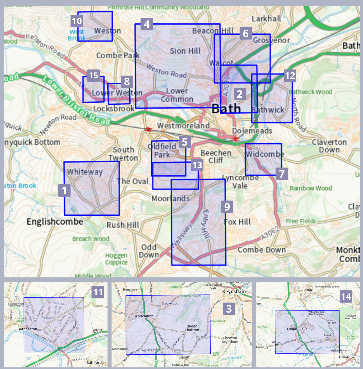
For Phase 1 of our Liveable Neighbourhoods programme, applications submitted by Ward Members, using an assessment methodology, identified 48 potential areas. Of these, we are prioritising the 15 areas below.
View the report on the selection of priority areas
- Southdown, Bath: Mount Road (Area 1)
- Bathwick, Bath (I): Area bounded by Sydney Place, Great Pulteney Street, St Johns Road and Bathwick Street (Area 2)
- Publow with Whitchurch and Saltford: Whitchurch and Queen Charlton village (Area 3)
- Kingsmead and Lansdown, Bath: Circus, Lower Lansdown, Marlborough Buildings, Royal Victoria Park and Cork Street area (Area 4)
- Oldfield Park, Bath: Oldfield Lane and First, Second and Third Avenue (Area 5)
- Walcot, Bath Phase 1: London Road, Snow Hill, Kensington Gardens and adjacent roads (Area 6)
- Widcombe and Lyncombe, Bath (I): Church Street and Prior Park Road (Area 7)
- Newbridge, Bath (I): Chelsea Road (Area 8)
- Widcombe and Lyncombe, Bath (II): Entry Hill (Area 9)
- Weston, Bath: Southlands (Area 10)
- Batheaston, Bathavon North: Morris Lane and Bannerdown (Area 11)
- Bathwick, Bath (II): (New) Sydney Place and Sydney Road (Area 12)
- Moorlands, Bath: Egerton Road and Cotswold Road (Area 13)
- Mendip: Temple Cloud (Area 14)
- Newbridge, Bath (II): Lyme Road and Charmouth Road (Area 15)
Future phases will provide the opportunity for additional areas to be taken forward, as part of the wider programme. For this first phase, however, we are only asking for comments and suggestions about these 15 areas.
View these areas on a map

This public engagement
During this next stage of the project, we are just focusing on the selected Phase 1 areas, and would like to know your views on the ones you know well. Tell us what is already good, and what could be improved, for any of these areas that you live in, work in, or regularly visit.
Your local knowledge will provide different perspectives and priorities to help us find the best possible design solutions for improvement. It’s also vital that we understand, and work to avoid or lessen, any potential impact of new schemes on neighbouring areas. We know that some areas have residents’ associations who have already been active collating similar information, and preparing plans for their areas. We will be meeting with their representatives and incorporating this information and these ideas into the our work
We will take forward the ideas that we crowdsource from you in this public engagement, to consider possible solutions and produce concept designs for the Phase 1 areas. There will then be the opportunity for residents, businesses and organisations to be a part of the co-design stage, helping to improve their environments and create healthier communities, with a better quality of life.
