Select a topic below to read in more detail.
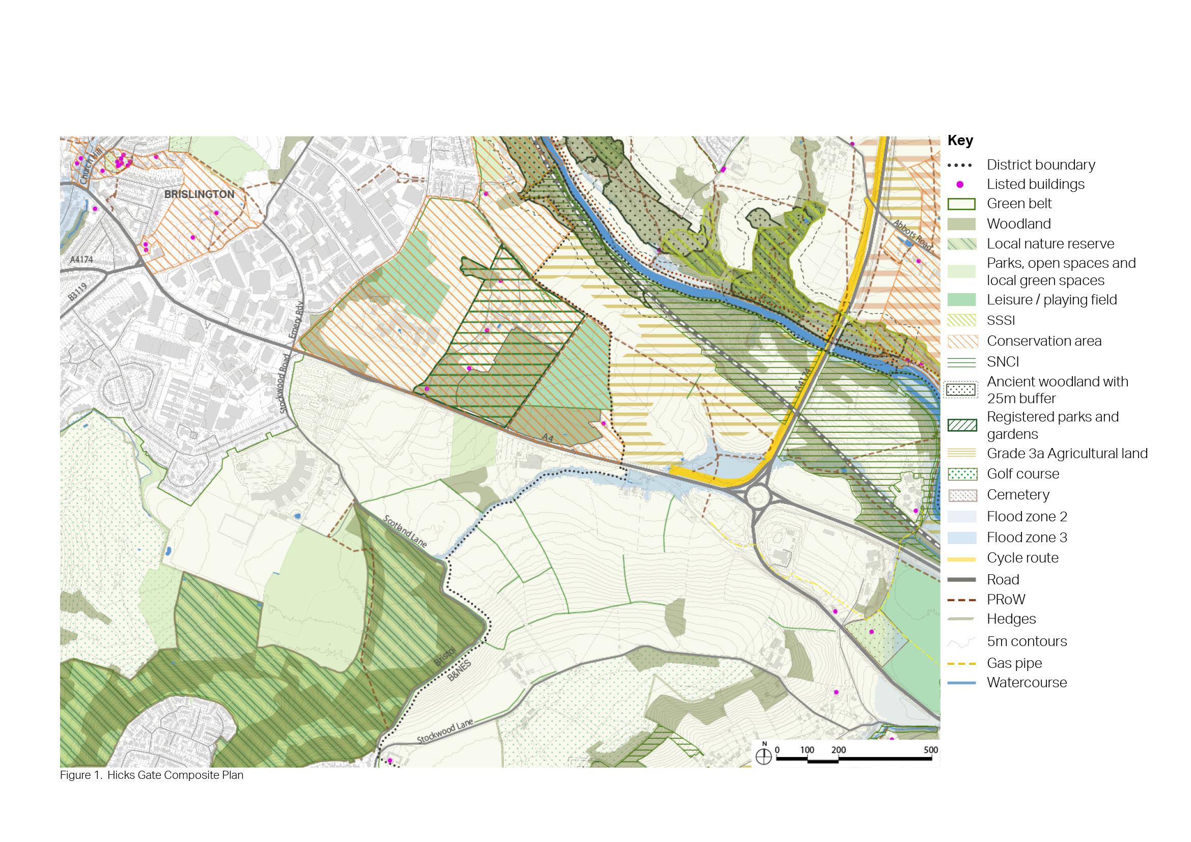
6.71 The Hicks Gate area is in the Green Belt and stretches west from the Hicks Gate roundabout to the local authority boundary with Bristol, including land to the north and the south of the A4. The wider area, which includes land within Bath and North East Somerset as well as Bristol City Council, largely comprises of agricultural fields typically used for grazing, with a network of public rights of way. This wider area includes to a range of sports pitches, Brislington House, St Brendan’s Sixth Form College, allotments and the Brislington Park and Ride Site.
6.72 The centre of Bristol is within 4km and Keynsham town centre is within 2km.
6.73 The A4 is a strategic transport corridor between Bath and Bristol. It experiences significant congestion in both directions during peak times.
Figure 33: Context plan - Hicks Gate
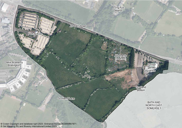
6.74 Bristol City Council has now published the new Bristol Local Plan Publication Version (November 2023) and ‘Policy DS12: New neighbourhood – Bath Road, Brislington’ proposes removing land from the Green Belt to the south of the A4 as identified on the aerial photograph below, for the development of 500-750 dwellings. The published Bristol Local Plan also states that if appropriate proposals adjacent to this location come forward, Bristol City council will work with Bath and North East Somerset Council to consider the impacts and opportunities, to assess infrastructure requirements and to ensure integrated and well-planned communities are created.
Figure 34: Extract from Bristol City Council Draft Local Plan showing area proposed to be removed from the Green Belt
- The wider area lies within Bristol City Council and B&NES Council. The local authorities would collaborate to enable the preparation of a comprehensive masterplan to deliver a high quality place to live and work.
- The Hicks Gate area is located within the Green Belt, which in this locality contributes to maintaining a separation between Bristol and Keynsham, and preventing the merger of the city and town. The Strategic Green Belt Assessment (WECA) assesses the wider area as two land parcels (P78 and P79) as having the following contribution to each of the NPPF Green Belt purposes:
- Purpose 1 - checking the unrestricted sprawl of large built-up areas: P78 and P79 significant contribution
- Purpose 2 - preventing the merger of neighbouring towns: P78, and P79 significant contribution
- Purpose 3 – safeguarding the countryside from encroachment: P78, and P79 significant contribution
- Purpose 4 - Preserving the setting and special character of historic towns: P78 limited / no contribution, P79 moderate contribution
- In order for development to be progressed in the wider area 'exceptional circumstances' would need to be demonstrated in order to justify removing land from the Green Belt. In the Bristol Local Plan Publication Version (November 2023) Bristol City Council is proposing to remove land from the Green Belt within the Bristol administrative area.
- This area has primarily been considered for its potential as a residential led development, coupled with the opportunity for employment led regeneration within the existing and adjacent areas of Bristol. One of the options to be considered as part of this consultation is whether there should be a section of the development area within Bath and North East Somerset that is more focused on the provision of employment floorspace.
- The A4 is a strategic route for vehicles and for freight. The introduction of segregated facilities for walking, cycling, public transport, plus green infrastructure and crossing points would be expected to ensure mobility for residents and mitigate the severance effect of the strategic road.
- As part of comprehensive development there is potential for the Brislington Park and Ride facility in Bristol to be relocated to land within Bath and North East Somerset closer to the Hicks Gate roundabout and in so doing becoming a transport interchange. This would mean that in-bound traffic using the Park and Ride would not pass through the proposed development area.
- The delivery of a transport interchange at Hicks Gate offers the potential to provide a broader range of sustainable connections with surrounding communities, including Keynsham and Bristol’s East Fringe. This could include additional bus services, active travel connections, and shared mobility facilities such as E-car clubs, hire bikes and e-scooters. It also would provide access to bus services on the Bristol Bath Strategic Corridor (BBSC), which will benefit from journey time improvements provided by the BBSC project.
- There are few footpaths in Hicks Gate, reducing connectivity within and through the area. The A4 severs movement across the area and cycling is restricted along this busy route. Cycle routes could be relocated away from the A4 to provide active travel links and improve the air quality.
- In terms of access to natural spaces, there is no connection to the River Avon and Stockwood Vale Golf Course restricts access to the wider countryside to the south.
- The landscape setting within the Hicks Gate area is sensitive, particularly in relation to the land immediately to the south of the A4 before the land slopes upwards. This area has a coherent landscape with small to medium late or post medieval permanent pasture (mostly) fields and excellent original, tall hedgerows.
- Existing hedgerows within the area are an important resource for associated wildlife. They need to be integrated in the new development and any hedgerow loss must be compensated at some other areas in line with the BNG and nature recovery requirements and strategies.
- The issue of the potential adverse impact on the water quality of the stream within the site should taken into account and mitigations should be applied.
- There are very few residents currently in the Hicks Gate area. One of the challenges will be to create a community with appropriate infrastructure and mix of uses.
6.75 The priorities and objectives for the Hicks Gate Area are set out below. Many of the priorities can be addressed by new development, and site options have been selected in response to the key issues, priorities and objectives. However, there are some priorities that won’t be addressed through new development but will be addressed through other policies in the Local Plan or initiatives undertaken by the Council or by other stakeholders.
6.76 The options proposed have been informed by a suite of Evidence Base material covering transport, landscape character, ecology and many other subjects. Following a comprehensive analysis of the constraints and opportunities, partly formulated through a series of design workshops, the following emerging priorities and objectives are proposed to help shape the placemaking aspirations and provide substance to the opportunity for strategic development at Hicks Gate. These are:
- Maximise the delivery of housing that is affordable in response to social and economic needs, and local demographics.
- Deliver zero-carbon homes and a built environment that seeks to meet the challenge of climate change by delivering a development that is both resilient and enduring.
- Consider the opportunities to deliver a greater proportion of employment led development within the Bath and North East Somerset area.
- The development will be compact, with an efficient use of the available land predicated on a well-balanced housing density, and a mix of house sizes, typologies and tenures.
- Development at Hicks Gate will seek to complement existing provision of services and amenities providing for the needs of both new and existing communities.
- The land use mixes across the site should be flexible, balanced and complementary with residential, community and leisure facilities, local services, retail, employment, offices and studios, all woven together to create a place that is truly designed for a healthy work-life balance.
- Reduce the need to travel, particularly by retaining and providing jobs, services and community facilities at suitable locations close to residential areas.
- Safeguard existing habitats and seek opportunities to deliver at least 20% biodiversity net gain with a strong network of hedgerows and flower rich verges throughout.
- Promote strategic green infrastructure and compensatory improvements in the remaining Green Belt gap between Bristol and Keynsham.
- Provide a range of sports, recreational facilities, parks and open spaces incorporating existing landscape assets to enable new residents to have an easy access to nature and promote active modes of travel.
- Provide tree-lined streets and public spaces to promote a sense of well-being as well as providing shading and cooling in the summer months and contributing towards the development’s climate change resilience capabilities.
- Integrate natural water management solutions to achieve resilient places to respond to the challenge of water stress by integrating sustainable urban drainage systems (SuDS), rain gardens, permeable pavers and rooftop gardens.
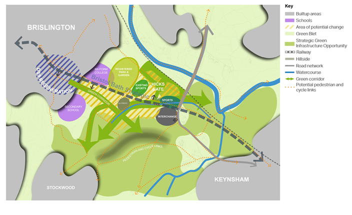
6.77 The diagram below represents these conceptual themes:
Figure 35: Concept plan - Hicks Gate


