The central proposal in this scheme is to create cycle lanes on both sides of Upper Bristol Road, between the junctions with Charlotte Street and Midland Road.
We have made a number of changes to our plans, based on your feedback from our previous consultation. Select a topic below, to read in more detail about the amended proposals in our Traffic Regulation Order.
The cycle lanes will be separated from motor traffic in two ways:
- Using bollards and splitter islands (‘light segregation’) to separate cyclists from other vehicles
- Providing new types of bus stops that enable cyclists to remain within the cycle lane, even if there is a stationary bus
New designs for light segregation
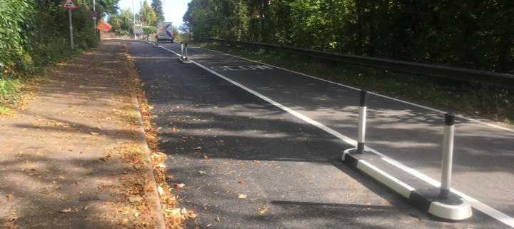
We've changed our proposal for ‘light segregation’ measures, to separate the cycle lanes from motor traffic. We had planned to use splitter islands at the start of the cycle lane, followed by bollards called ‘wands’ at regular intervals, to prevent traffic from entering the cycle lanes.
Following feedback from the emergency services, we still intend to use the islands at the start of the cycle lane, but the wand measures are now spaced every 15 metres with ‘mini orca’ measures in between.
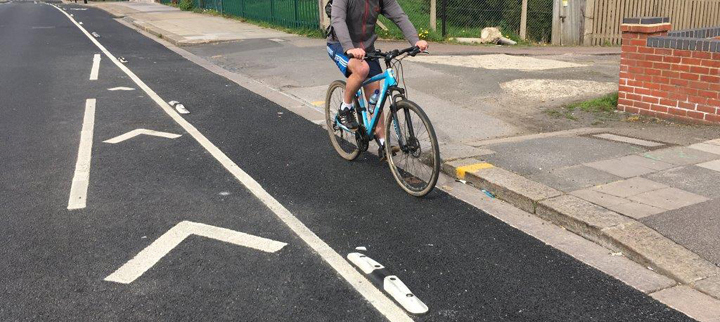
An example of a mini orca cycle lane separator (Copyright: Rediweld Traffic)
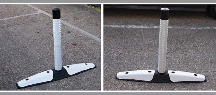
An example of a wand cycle lane separator (Copyright: Rediweld Traffic)
An example of a splitter island cycle lane separator (Copyright: Rediweld Traffic)
Parking stands
We would provide 6 cycle parking stands along Upper Bristol Road. Their proposed locations are labelled on the technical drawings for the scheme
Bike lockers
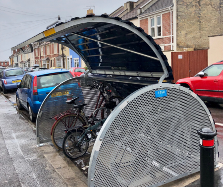
We also intend to provide one or two secure, on-road bike lockers in the Zone 6 parking area, depending on the level of demand. These are secure, covered facilities that can only be opened by people who have subscribed and have access to the lock. They are particularly useful for people who have nowhere to store a bicycle at home.
An example of an on-road bike locker
There would be a small annual fee which would be used to cover the cost of the upkeep of the locker. We will be consulting on potential locations in the near future, and we are keen to hear from all residents in Bath who would be interested in these lockers.
The original proposals included 'floating' bus stops (where the cycle lane passes between the pavement and an island which people use to get on or off a bus) at all 4 stops within the scheme. To make space for parking bays which we are proposing, we have amended the bus stop design to feature ‘boarders’ at 2 of the 4 stops.
Floating bus stops
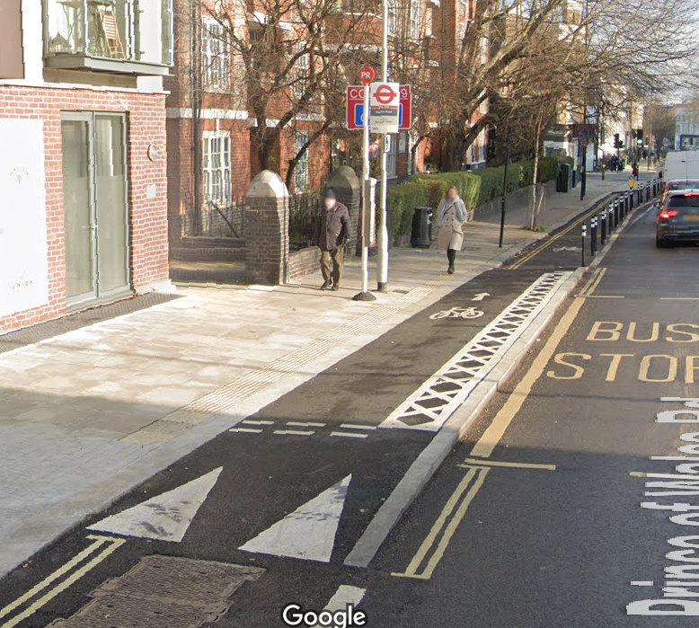
At these 'floating' bus stops, the new cycle lanes will run next to the kerb, and the bus stops will be on 'islands' set into the roadway. This means that you will need to cross the cycle path when you get onto or off a bus, but you will have priority over cyclists, with crossing points clearly marked, like a standard zebra crossing.
To ensure that cyclists slow down and look out for bus users, there will be a ramp when approaching a bus stop and textured paving. The cycle path surface will rise to match the pavement at bus stops, so that the new route onto the bus shouldn't cause additional problems for wheelchair users or buggies
The image below is similar to our proposal for Upper Bristol Road, but our island is slightly narrower which means the bus shelter would be on the pavement. We would also use red coloured surfacing in the cycle lane.
Example of a floating bus stop (Copyright: Google)
Bus stop boarders
With bus stop boarders, the cycle lane goes up a ramp to be level with the pavement, but there is no island. This design is being used where there is not enough road space to provide the island in the floating bus stop design.
Unlike the floating bus stop, it is not possible to provide a zebra crossing in the cycle lane. There will be signs, textured paving and road markings to make sure cyclists know they need to give way to bus users on this shared piece of pavement.
The image below shows a similar design, although our proposal also includes a red coloured cycle lane where it passes at the same level as the pavement, and additional signs and road markings to tell cyclists to give way to pedestrians.
An example of a bus stop boarder (Copyright: Google)
We are planning to extend the existing 20mph speed limit westwards, to the junction with St Michael’s Road. Together with the new road layout and cycle lanes, this will help reduce the speed of motor traffic.
View a map of the area covered by the proposed 20mph speed limit
The most frequently expressed concern at the last consultation related to the loss of car parking bays. Although the proposals include replacement parking spaces in other nearby streets, there is still a need for deliveries and servicing requirements to homes and businesses in Upper Bristol Road.
We have therefore amended our proposals to include some short sections of car parking. Where possible, these will be 'floating' bays where the cycle lane passes on the inside of the parking bay, as this is safer for cyclists when passing parked vehicles.
These would all offer time-limited 30-minute stays between set hours (detailed below), to help make parking regularly available during the daytime, with unlimited stays outside of those hours.
Changes at the Charlotte Street end of the road:
- A new Parallel Zebra crossing for pedestrians and cyclists (see more information below)
- On the north side of the road, a floating bay with 4 spaces to the east of this crossing (30-minute maximum stay, 8am to 6pm), and a floating bay with 6 spaces to the west (4 30-minute maximum stay, 8am to 6pm, and 2 30-minute maximum stay, 8am to 11pm)
Floating parking bays
The parking bays on the north side of Upper Bristol Road will be located between the carriageway lane for motor traffic and the cycle lane, referred to as ‘floating’ parking bays.
This gives better protection for cyclists when passing parked vehicles. An example of a floating parking bay is shown below:
Example of a floating parking bay (Copyright: Google)
Upper Bristol Road will be narrower, once the cycle lanes are installed. We are therefore planning time restrictions for these activities, to avoid potential congestion caused by delivery vehicles at the busiest times of the day.
To enable motor vehicles to load and unload without blocking the road, we are adding a loading bay and a layby.
Layby outside the former Hinton Garage
A new layby will be provided here as part of the new development currently under construction, to cater for deliveries to this development, and minibuses or ambulances collecting or dropping off passengers. It would include double yellow line restrictions which allow loading and unloading.
Loading bay outside The Hop Pole public house
The proposed design provides a cycle lane going through the loading bay outside The Hop Pole public house, stepped approximately 50mm above road-level. It enables cyclists to continue on the carriageway most of the time, when there is no vehicle in the loading bay. When the loading bay is in use, cyclists will be able to join a short section of shared-use pavement, to bypass the loading bay without being obstructed.
The loading bay would be time-limited to 30-minute stays, to enable deliveries to the pub or nearby properties, and dropping off or picking up passengers. It is necessary to provide the loading bay in this way because if it were on the outside of the cycle lane it would be difficult for vehicles to see past it to overtake due to the bend in the road.
The existing Pelican crossing at the Nile Street junction needs replacing as it has reached the end of its serviceable life. We are proposing a new Parallel Zebra crossing, relocated to the east of the junction. This will enable us to provide car parking at the widest point of Upper Bristol Road.
Parallel Zebra crossings are for pedestrians and cyclists, and this new one will provide an improved link to and from Nile Street.
Example of a Parallel Zebra Crossing (Copyright: Google)
View the detailed plans for cyclists from our previous consultation.

